GeoServer
Refractions Research Inc.
Victoria - British Columbia - Canada
http://geoserver.sourceforge.net
http://www.refractions.net
|
GeoServer |
Developed in Part by Refractions Research Inc. Victoria - British Columbia - Canada http://geoserver.sourceforge.net http://www.refractions.net |
|
About GeoServer
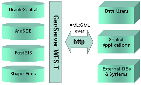 GeoServer is written in 100% pure JavaTM and is deployed as a J2EE (Java2 Enterprise Edition) web application. GeoServer is compatible with standard J2EE servers, such as Apache Tomcat and Resin. GeoServer is "transactional", meaning it supports feature editing and feature locking. Transaction support is important for providing concurrent editing of features over a network. GeoServer is the OpenGIS reference implementation for Web Feature Servers. It passes all of the OpenGIS Conformance, Interoperability and Testing Environment (CITE) tests for WFS-T capabilities. GeoServer supports several standard industry databases out of the box, including Oracle Spatial, ArcSDE, PostGIS and ESRI Shape Files. GeoServer supports OpenGIS GML version 2.1.
GeoServer conforms to the OpenGIS Web Feature Server specification version 1.0.0.
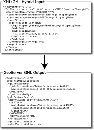
GeoServer XML
Development Roadmap
Upcoming GeoServer Release Version: 2.0
|
Development Team The Open Planning Project Created the first (1.0) version of GeoServer and provide development leadership for the GeoServer project. Refractions Research Inc. Contributed validation features, a web-based configuration interface, and numerous enhancements to the 1.2 release of GeoServer.
Support Refractions Research Refractions offers consulting services in spatial systems architecture, PostGIS/PostgreSQL database implementations, as well as custom enhancements to PostGIS.
For more information, please contact:
Paul Ramsey, President |
|||